In late 2017 the Michigan Department of Environmental Quality (MDEQ) asked MCWC to provide our stream monitoring data of Twin and Chippewa Creeks in Osceola County. MCWC started monitoring local streams because of Nestle Ice Mountain’s desire to increase its water taking.
Letter to MDEQ:
January 10, 2018
Dear C. Heidi Grether, Director of DEQ
Jon W. Allan, Director of Office of Great Lakes
We appreciate the opportunity to respond to your letter of December 20th, 2017 and
provide you with the findings of our data collection efforts over the summer of 2017.
We will also share our position on the environmental status of Twin and Chippewa
Creeks in Osceola Township in Osceola County.
According to a prior communication from you to Michigan Citizens for Water
Conservation (MCWC), the January 5, 2016 SSR authorization was incomplete and a
conditional authorization only in the sense that Nestle must also obtain a permit under
Section 17 of the Safe Drinking Water Act to increase its water pumping rate from 150
gallons per minute to 250 gallons per minute; NOT the 250 gallons per minute to 400
gallons per minute stated in your December 20th letter. Also in your December 20th
letter, you stated the permit application had NOT been submitted BEFORE the site
specific review was APPROVED. We find this to be irregular and wonder whether
procedural fidelity was followed.
MCWC objects to the lack of public notice and awareness, prior to the DEQ’s SSR Jan.
2016 authorization. The citizens of Michigan deserve as much public notice and
transparency as possible in all the permitting actions of the DEQ. Clearly MCWC feels
the DEQ needs to do better in both public notice and transparency with these types of
permitting actions in the future.
Before we reference our summer 2017 survey data, MCWC would like to reference the
113 page detailed comments to the DEQ concerning the White Pine Springs Well 101
application by the FLOW organization. Dr. Hyndman and Dr. Luttenton are world-class
scientists who documented the significant environmental damages done to Twin and
Chippewa Creeks by the water taking by Nestle at 150 or 250 gallons per minute.
It is also important to note, according to the United States Weather Service, the yearly
rainfall rates for mid-Michigan was ten inches above normal for the period ending in
July, 2017. This area includes the entire area surrounding Evart, including the
Township of Osceola where Twin and Chippewa Creeks are located.
The MCWC Summer 2017 survey on Twin and Chippewa Creeks was conducted on
July 31, 2017 by John McLane and Jim Maturen, two MCWC board members. John is
a surveyor and the retired lead surveyor for the largest natural gas company in
Michigan. Jim is a retired Michigan State Police Officer and a retired County
Commissioner from Osceola County.
We have also attached Jim Maturen’s report on this survey and the summary reference
to the DNR’s whirling disease survey on Twin and Chippewa Creeks conducted in 2000.
It also should be noted that John McLane led a group of three DNR personnel on a 3-v
hour site survey of Twin and Chippewa Creeks in late June of 2017.
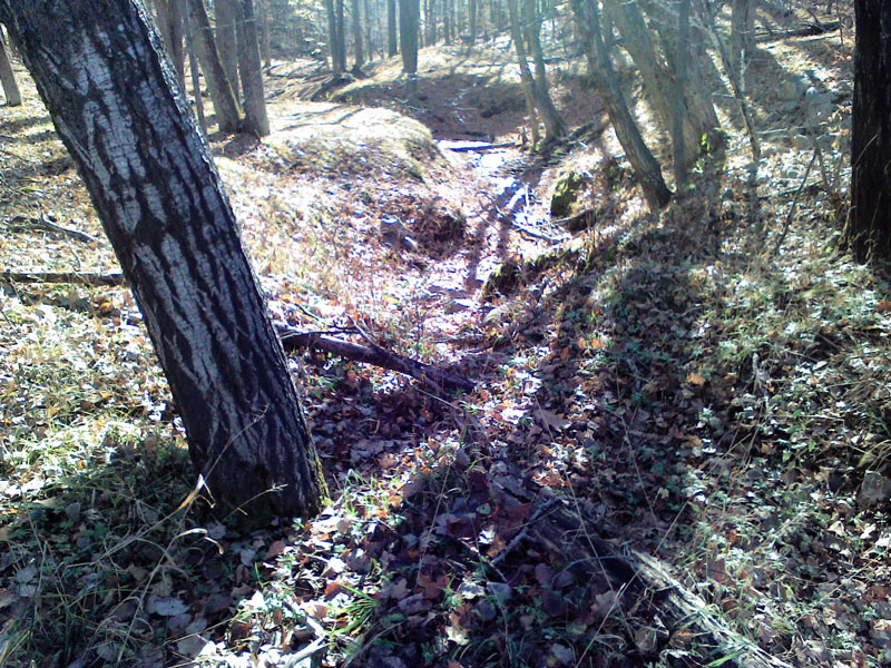
The MCWC survey design was simple. Measure the depth of water in the culverts.
Measure the normal historic water mark level in the culverts from the bottom of the
culverts. Subtract the first measurement from the second to determine whether there
was surface water loss. Take the water temperature.
Instruments used were a yard stick and temperature sensor from sport fishing gear.
MCWC survey data – July 31, 2017 – Twin and Chippewa Creeks (pdf file of the letter)
It is a matter of public record that the Nestle Corporation offered at an Osceola
Township meeting in April of 2017 to replace ALL CULVERTS in Osceola Township free
of charge. So evidently, should the DEQ become familiar with a culvert in need of
replacing, the Nestle Corporation probably would like to buy a new one.
MCWC believes the significant loss of surface waters in Twin and Chippewa Creeks is
significant environmental damage that is primarily the result of the water takings by the
Nestle Corporation. We believe the surface water loss combined with the significant
aquatic life loss on both creeks constitute major environmental damage and warrant
establishing a moratorium on Nestle water taking from White Pine Springs well 101,
until such time as the historic normal surface water levels are restored to both Twin and
Chippewa Creeks.
While it is important to recognize that DEQ must protect Twin and Chippewa Creeks
from further environmental damage, it is also important to understand the difficulties the
DEQ has had in attempting to administer and monitor the Nestle water taking permits.
Clearly, reliance upon administrative rules that allow Nestle to summarize their
withdrawals and report annually, leaves the DEQ without important information that the
DEQ should have and the public has a right to. MCWC feels the DEQ should review
the monitoring and reporting requirements for large scale water taking and revise them
to provide much more public transparency and real data availability in the monitoring
process.
Finally, MCWC believes the DEQ needs to change the monitoring and data collection
process and rules for large scale water takers to require as a condition of permitting that
the monitoring and data collection be done by the US Geological Survey.
If you have questions or you would further like to discuss the Summer 2017 survey
and/or the ideas presented here, please feel free to contact MCWC.
Sincerely,
Board of Michigan Citizens for Water Conservation
Peggy Case, President 231-275-2244 Jeff Ostahowski, VP 231-598-9166
John McLane, Jim Maturen, Christopher Swier, Karen Turnbull, Wendy Nystrom,
Diane Weckerle, Pam Gilbert, Shannon Abbott, Ken Ford
Attachments included
CC:
Gov. Rick Snyder
Angela Ayers
Michael McClellan
Tim O’Brien
Teresa Seidel
Kimberley Fish
James Milne
Learn more about Nestle’s recent activities in Michigan and MCWC’s response.
Also published on Medium.